Soil Water Content Measurements


Overview
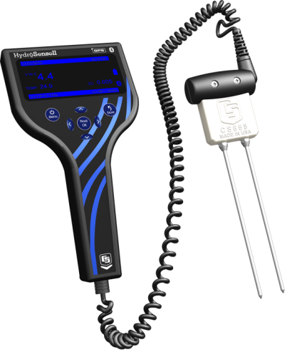
The HS2 is the handheld display for the new Hydrosense II soil-water sensor. When paired with either the CS658 or CS659 portable soil-water probes, it replaces the previous Hydrosense soil-water system. It features a new handheld display and a new probe design. The HS2 handheld has been designed to be compact and portable, with the layout of the buttons allowing for operation with one hand.
Read MoreBenefits and Features
- Compact and lightweight
- Read real-time soil-water content measurements in the field
- Large LCD display for easy operation
- Onboard data storage for up to 1500 points
- Onboard GPS for geotagging measurements
- Bluetooth connection to PC software
- Export to Google Earth, GPX and CSV
- Probe redesign for easy insertion and removal from soil
Technical Description
Handheld Display
The display consists of a 76 mm LCD and four navigation buttons that make changing settings and taking measurements as easy as possible. An integrated GPS tags each measurement with a latitude and longitude.
Zones can be created on the unit which group measurements together so that average soil moisture can be calculated for an area. The current position and zone are shown on the display so that measurements can be taken in the same zone.
Data storage has been added to allow more than 1000 measurements to be stored on the device. The data can then be downloaded to a PC via Bluetooth for viewing and archiving.
Soil Moisture Probe
The new soil moisture probe uses the same accurate measurement technique as the old probe, but the probe housing has been redesigned to aid insertion into and removal from hard soils. The probe rods are secured to the probe housing with ferrule nuts to provide extra stability during insertion. A molded plastic grip connects the sensor cable to housing to provide better grip.
Software
New PC software has been developed to make the most of the data storage capability of the HS2. The software connects to the HS2 via Bluetooth to avoid the need for extra cables.
The software allows the user to:
- View data in table and chart views
- Edit zone positions and sizes
- Change device settings
- Export data to CSV to interface with 3rd party software
- View zones and measurements in Google Earth
Images


Related Products
Compatibility
System
The HS2 is the display used in the Hydrosense II System.
Water Content Sensors
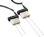
The water content sensor is ordered as an option, and may also be purchased separately. Either the CS658 or CS659 can be used with the HS2. The CS658 has 20-cm rods, and the CS659 has 12-cm rods.
Note: The CS658 and CS659 cannot share rods (i.e., 12-cm rods cannot be used with the CS658, and 20-cm rods cannot be used with the CS659).
Specifications
| Measurements Made | Volumetric water content (VWC) of porous media (such as soil) |
| Required Equipment | HS2 is a complete system. |
| Soil Suitability | Short rods are easy to install in hard soil. Suitable for soils with higher electrical conductivity. |
| Rods | Replaceable |
| Sensors | Interchangeable sensors; can swap the 12 cm and 20 cm sensors with the reader. |
Handheld Display |
|
| Display | 128 x 64 pixel graphic LCD |
| Backlight | Blue and white LED (brightness-adjustable) |
| GPS Accuracy |
|
| Bluetooth Range | ~10 m (~30 ft) |
| Data Storage | > 1000 records (ring memory) |
| Zone Storage | > 100 records |
| Power Supply | 6 Vdc, 4 AA batteries |
| Battery Life | 6 to 12 months (typical usage) |
| Dimensions | 200 x 100 x 58 mm (7.9 x 3.9 x 2.3 in.) |
| Weight | 340 g (12 oz) |
Typical Power Consumption of Display |
|
| Sleep | 20 µA |
| Backlight Off | 2 mA |
| Backlight at 60% | 18 mA |
| Backlight at 100% | 30 mA |
| GPS Active | 35 mA |
| Bluetooth Active | 30 mA |
Probe Options |
|
| -NOTE- | The CS659 and CS658 cannot share rods. |
| Water Content Accuracy |
|
| Volumetric Water Content Resolution | < 0.05% |
| Volumetric Water Content Range | 0% to 50% VWC |
| Cable Type | Spiral |
| Cable Length | 250 cm (98 in.) extended |
| Rod Diameter | 5 mm (0.14 in.) |
| Rod Length |
|
| Body Dimensions | 100 x 92 x 40 mm (3.9 x 3.6 x 1.6 in.) |
| Weight | 450 g (15.9 oz) |
Resources and Links
Product Brochures
FAQs for
Number of FAQs related to HydroSense II: 19
Expand AllCollapse All
-
Four AA batteries power the HS2. The batteries are user replaceable.
-
-
When Deficit Mode is used, a negative RWC value indicates that the water content is below the dry reference. For more information, see the "Water Deficit Data" subsection in the "Operation" section of the HS2 Instruction Manual.
-
No. The original HydroSense was not capable of storing data. The HS2 produces a CSV file that can be merged into an existing data file used for HydroSense data. However, the CSV output file from the HS2 will include additional parameters that were not measured by the original HydroSense.
-
Not necessarily.
- If the computer being used is Bluetooth enabled, an adapter is not needed.
- If the computer being used is not Bluetooth enabled, an adapter can be purchased (pn 28411, Bluetooth 2.1 USB Micro Adapater).
-
As stated in the "Connecting via Bluetooth" subsection in the "Data Storage and Retrieval" section of the HS2 Instruction Manual: “The first time the HydroSense II unit is used with a new computer, the computer and HydroSense II must be ‘paired’ before a connection can be made. The pairing code is ‘1234.’” For more information, see the "Connect to a Device" subsection of the "Quickstart" section of the HydroSense II Support Software User Guide.
-
No. The displays and sensors are not interchangeable between the HydroSense and HydroSense II.
-
A VWC reading of (---) indicates either that the water content of the soil is greater than 50% or that the EC (electrical conductivity) of the soil is out of range. For more information, see Sections 6.3, 6.4.4.3, and 6.4.4.4 of the HS2 Instruction Manual.
-
The water content data file is configured as ring memory, and it can hold more than 1,000 values. When the file becomes full, the oldest data are overwritten and storage continues.
The zone data file, in contrast, is configured as fill-and-stop memory. The zone data file holds a list of zones that have been created. A zone is created each time a datum is stored in a new location. Each zone record contains the center position (latitude and longitude), radius in meters, and the zone name. The zone data file can hold more than 100 zones, but when the zone data file is full, the DISK FULL error is displayed, and a new zone cannot be created until an old zone is removed. To remove a zone, follow these steps:
- Connect to the HS2 using the HydroSense II Support Software.
- Navigate to the Map View.
- Right-click an unneeded zone, and select Remove.
-
No. The HS2 uses Bluetooth communication.
Privacy Policy Update
We've updated our privacy policy. Learn More
Cookie Consent
Update your cookie preferences. Update Cookie Preferences


